
1.11.2006
Survivor: Landsat
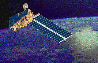 It's fun, but not always easy, keeping up with the latest installments in the decades-long soap opera/reality series that is the Landsat program.
Never a shortage of drama. As we saw in December, close to being voted off the island, Landsat found itself rescued by the White House (Office of Science and Technology Policy) in the form of John Marburger's latest Landsat memo which reversed the earlier decision on the fate of the program (see, Aug. 13, 2004 directive to transition the collection of land remote sensing data to NPOESS. A program which struggles with its own challenges. But never mind that.) NASA is now authorized to acquire a free-flying Landsat spacecraft. Hurray. While the two rickety old Landsat satellites suffer glitches and breakdowns in orbit, Space.com reports NASA says it will move quickly to issue a solicitation, accept proposals and award a contract to build a dedicated Landsat spacecraft, which the U.S. Geological Survey will operate.
And yes, as OSTP confirmed, it remains the government's goal is to make Landsat a permanent program rather than a series of independent missions. Still.
Everyone knows about the great contributions made by Landsat imagery for more than 30 years. As OSTP says, Landsat images are used in "land use/land cover change research, economic forecasting, disaster recovery and relief, and the scientific study of human impacts on the global environment."
All true. But I also like occasionally to consider uses of Landsat that sometimes gets overlooked. Clever lawyers for years have been bringing Landsat and other satellite data into court for use as evidence in all kinds of litigation.
For example, here's an update this week from the heartland (actually, AP via The Kansas City Star) on the USDA using Landsat satellite images to prosecute farmers for fraud.
Apparently just the threat of lawyers getting hold of a Landsat image or two can be a powerful enforcement mechanism or deterrent. Said one agricultural economist (not a lawyer) who reportedly warned farmers on his e-mail distribution list of the increasing use of satellite imagery in courtrooms, "what it does is keep honest folks honest."
In its Compliance Highlights for 2005, USDA's Risk Management Agency (RMA) says it "continues to use remote sensing data and related technologies to support its program compliance efforts and aid RMA personnel and outside customers working on Agency mission critical projects. RMA uses remote sensing to identify waste, fraud, and abuse in its programs using Landsat 5 and 7 data to support investigations of conspiracy, fraud, false claims, and false statements to the Department of Agriculture. Based upon the success of using remote sensing in the past, RMA has provided remote sensing training to a number of its compliance investigators. Investigators are trained to acquire Landsat 5 and 7 imagery from the USDA Image Archive and make preliminary determinations either to approve a crop insurance claim, or forward it to a remote sensing expert for further investigation. Such training has increased RMA image requests to the USDA Image Archive."
And see my post, Orbiting Witnesses.
Just a few examples of lawyers making use of Landsat, while it survives. And the adventure continues, because earth gives Landsat a lot to look at every day...
And Landsat gives it right back.
![]()


